High Water Venice: Essential Guide and Preparation
- 5 min read
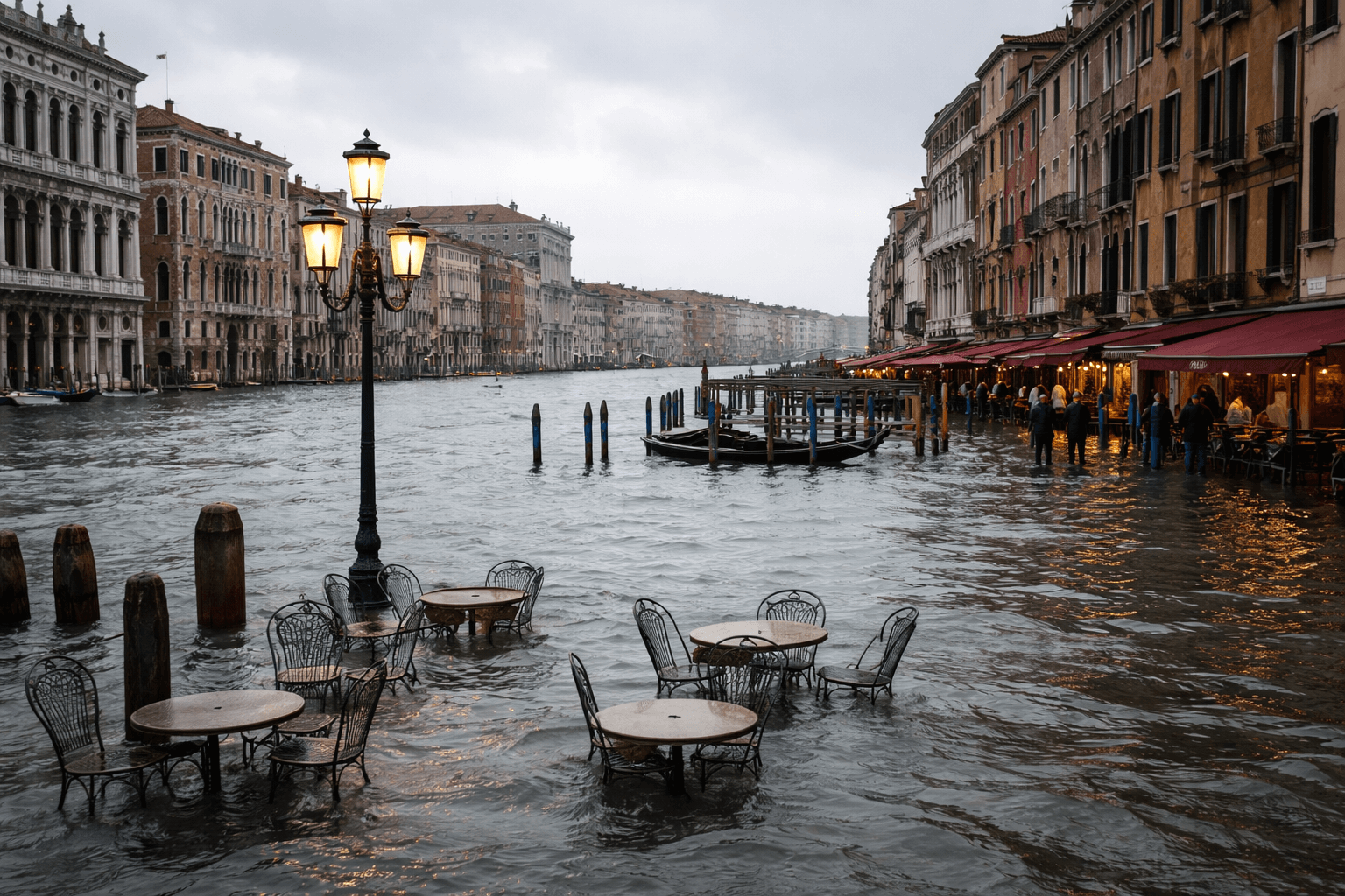
Visiting Venice during Acqua Alta might seem daunting, but with the right information, it becomes a manageable and even fascinating experience. Because of seasonal tides, certain areas of the city may flood as Venice lives in a unique balance between water and architecture. Knowing the causes, timing, and proper behavior allows you to navigate safely and enjoy your trip without surprises.

Venice City Pass all Inclusive 72h
What is Acqua Alta and Why It Matters to Tourists
High Water is a natural phenomenon that deeply impacts the visitor experience. It occurs when the sea level rises above normal, flooding urban areas—particularly the lowest spots like St. Mark’s Square. Because it is tied to the unique shape of the Venetian lagoon, it is not an “emergency” but a historical characteristic of the city.
For tourists, it is a crucial variable to understand. While water in the streets can slow down movement, it rarely ruins a trip if you are prepared. Today, the city is much more protected thanks to the MOSE system, a series of mobile barriers that rise to block the sea during exceptional tides (usually over 110–130 cm).
The Causes of High Water
Acqua Alta results from a combination of natural and climatic factors:
- Astronomical Tides: The natural cycle of the moon.
- Weather Conditions: Low atmospheric pressure and the Scirocco wind (blowing from the southeast) push water from the Adriatic into the lagoon.
- Climate Change: Rising sea levels have increased the frequency of these events.
When It Occurs and How to Recognize It
- Season: Most frequent in autumn and winter (October to February).
- Thresholds: A tide is considered “high” when it exceeds 90 cm. At 110 cm, about 12% of the city is flooded.
- How to stay informed:
- Sirens: A system of sound alerts warns the city before the water arrives.
- Apps: Download “Hi!Tide Venice”, the official app for real-time tide forecasts and to see which streets are currently flooded.
- Online: Check the Venice Municipality Tide Center.
Venice City Pass all Inclusive 72h
How to Prepare
- Footwear: Bring or buy rubber boots (stivali di gomma). You will see shops selling disposable plastic overshoes, which work for light flooding but can tear easily.
- Navigation: Use the elevated walkways (passerelle) set up by the city along main pedestrian routes.
- Accommodation: Most hotels are well-equipped with elevated entrances and will provide tide updates to guests.
Venice Under the Water: What’s Really Down There?
Venice does not “float.” It rests on an extraordinary engineering system:
- Wooden Piles: Millions of larch and oak piles were driven into the marshy ground centuries ago. Because they are submerged in oxygen-free mud, they do not rot—they petrify and become as hard as stone.
- Giudecca Canal: While some streets flood with just a few centimeters of water, the Giudecca Canal is much deeper, reaching up to 12–17 meters.
Venice City Pass all Inclusive 72h
FAQ – Venice High Water
1. When is the water officially considered “high” in Venice?
A tide is officially classified as Acqua Alta when it exceeds 90 cm above the standard sea level. At this threshold, water begins to cover the lowest parts of the city, most notably St. Mark’s Square.
2. What exactly causes this phenomenon?
It is caused by a combination of three factors: the astronomical tide (influenced by the moon), low atmospheric pressure, and the Scirocco wind, which blows from the southeast and pushes Adriatic seawater into the lagoon. Climate change is also contributing to the increased frequency of these events.
3. How deep does the water actually get on the streets?
In most common cases, the tide fluctuates between 90 cm and 120 cm. It is important to remember that this number represents the tide level relative to a reference point, not the depth of water on the ground. For example, with a 100 cm tide, there would be about 20 cm of water in St. Mark’s Square.
4. What is the historical record for high water?
The absolute record occurred on November 4, 1966, when the water reached 194 cm. Another devastating event took place more recently in November 2019, reaching a peak of 187 cm.
5. How deep is the Giudecca Canal?
The Giudecca Canal is one of the city’s primary waterways and reaches a depth of approximately 12 meters, allowing for the passage of large vessels (though large cruise ships are now restricted).
6. Why don’t the wooden piles supporting Venice rot?
The millions of wooden piles are driven deep into the lagoon mud in an oxygen-free (anaerobic) environment. Without oxygen, the microorganisms that cause wood to decay cannot survive. Over centuries, the wood undergoes a mineralization process, essentially turning it as hard as stone.
7. How can I know in advance if Acqua Alta is going to happen?
Venice uses a very efficient warning system. The Tide Center issues daily bulletins, and if a significant tide is expected, the city activates acoustic sirens with different tones to signal the predicted level. There are also official apps like “Hi!Tide Venice” for real-time tracking.
8. What is hidden beneath the water in Venice?
Beneath the visible canals lies a massive engineering feat: a dense forest of wooden piles, layers of Istrian stone foundations, and a complex network of ancient sediments that have supported the city’s heavy palaces for over a thousand years.