

Venice: ACTV Daily Vaporetto Pass
Why the Official Vaporetto Map Is Essential
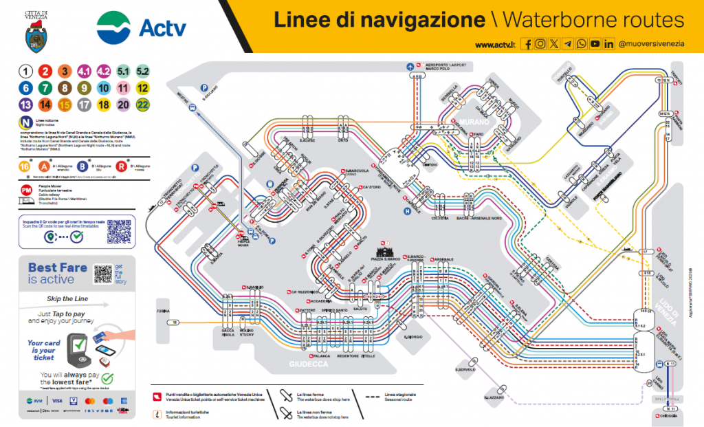
The map distributed by ACTV and the City of Venice is the reference document for finding your way around the city’s water routes. It is not just a tourist map: it details every single stop, active line, seasonal route, night service, and ticket point. It is the same document displayed at water bus stops and available at Venezia Unica sales points. Consulting it before leaving, or keeping a digital version handy during your stay, prevents the most common mistake for first-time visitors: boarding the wrong vaporetto, perhaps in the opposite direction, wasting valuable time in a city where every trip by water requires a bit of planning.
Click here to download it
How the ACTV Navigation Map is organized
Read the map starting from the key in the top left, where each line is represented by a number inside a colored circle: from line 1 to line 22, including variants 4.1, 4.2, 5.1, and 5.2 (which indicate the same circular route traveled clockwise or counterclockwise). Each color is unique and traces the route on the main map so you can visually follow a line from end to end.
In addition to numbered lines, the key highlights other essential elements:
- Night Lines (N): Includes line N (running via the Grand Canal and Giudecca Canal), the “Notturno Laguna Nord” (NLN) line, and the “Notturno Murano” (NMU) line, active when most daytime lines are suspended.
- Alilaguna (A, B, R): Orange, Blue, and Red Alilaguna lines are marked with an asterisk to show they are a separate service from ACTV, useful primarily for Marco Polo Airport connections.
- People Mover / Cable Car: The land funicular connecting Piazzale Roma, the Cruise Terminal (Stazione Marittima), and Tronchetto Island—ideal for those arriving by car or coach.
- Seasonal Line: Shown with a dashed line, indicating connections active only during specific times of the year.
- Stop Symbols: Symbols indicate where a line stops and where it passes through without stopping.
- Venezia Unica Ticket Points and Machines: Marked on the map to show where to buy or collect transit passes.
- Tourist Information: A dedicated symbol marks tourist offices along the routes.
- Real-Time Schedules: A QR code in the bottom left links to live departure times to check for delays.
Grand Canal and Historic Center Lines
At the center of the map, the dense network of colored lines crossing the San Marco Basin, the Grand Canal, and the Giudecca Canal represents the heart of Venice’s navigation system. Key transit hubs include Ferrovia (Santa Lucia train station), Piazzale Roma, Rialto, and San Marco / San Zaccaria. Around these hubs, lines branch out toward the various districts (sestieri), Tronchetto, and the southern waterfront areas of Santa Marta, San Basilio, and Zattere.
Venice vaporetto Ticket ACTV - 75 minutes
Lines to the Northern Lagoon Islands: Murano, Burano, and Torcello
To the top and right of the historic center, the map shows connections to the northern lagoon. Murano (serviced by stops like Colonna, Faro, Navagero, Venier, Museo, Da Mula, and Serenella) is accessible via multiple intersecting lines. Farther northeast lie Burano, Mazzorbo, and Torcello. The Marco Polo Airport connection is marked in the top right with an airplane icon.
Lines to Lido, Pellestrina, and Chioggia
On the right side of the map, Venice Lido appears as a long strip of land connected to the historic center via the Santa Maria Elisabetta (S.M.E.) hub. Continuing south, routes extend to Pellestrina and Chioggia, combining water transport with bus routes to cross Lido island where water transit pauses. Inner lagoon connections to San Giorgio Maggiore, Giudecca, and Sacca Fisola are clearly marked just south of the San Marco Basin.
Night Lines: N, Notturno Laguna Nord, and Notturno Murano
When daytime services end, night lines take over (indicated by an “N” circle):
- Line N: Operates along the Grand Canal and Giudecca Canal.
- Notturno Laguna Nord (NLN): Connects the northern lagoon islands.
- Notturno Murano (NMU): Serves Murano throughout the night.
Alilaguna: Orange, Blue, and Red Lines
Marked with an asterisk in the key, the Alilaguna Orange (A), Blue (B), and Red (R) lines are operated independently from ACTV. They provide direct water transport between Marco Polo Airport and key areas like San Marco and Murano.
People Mover
The People Mover land funicular links Piazzale Roma, the Cruise Terminal, and Tronchetto. While not a water bus, it is included on the map to assist travelers arriving by car, bus, or cruise ship.
Where to Buy Tickets
The map details sales channels for transit passes: Venezia Unica ticket offices, self-service machines, authorized retailers, online at veneziaunica.it, the official AVM Venezia app, and the Chat&Go service by muoversivenezia. Venezia Unica locations also sell tickets for local events, museums, and theaters.
Venice City Pass all Inclusive 72h
Frequently Asked Questions
- Where can I find the official Venice vaporetto map? Published by ACTV, it is available at Venezia Unica ticket offices, major water bus stops, online at actv.it and veneziaunica.it, and on the AVM Venezia Official App.
- How many vaporetto lines are shown on the map? The map lists numbered lines 1 through 22 (including 4.1, 4.2, 5.1, and 5.2 variants), night lines (N, NLN, NMU), and Alilaguna lines (A, B, R).
- What do the dashed lines mean? Dashed lines indicate seasonal routes active only during specific times of the year.
- Are Alilaguna lines included in standard ACTV tickets? No. Alilaguna is a separate operator (marked with an asterisk) and requires a dedicated ticket.
- How do I check real-time schedules using the map? Scan the QR code printed on the map with your smartphone to access live departure times.
- What does the People Mover symbol represent? It marks the land funicular connecting Piazzale Roma, the Cruise Terminal, and Tronchetto Island.